2019 New Zealand - Campervan 7 Dunedin & DONE
Zigzagged out of Invercargill then along fairly flat sheep and cattle ranch country heading to Fortrose. Here the view is the Toetoes Estuary, an area containing approximately 400 hectares of tidal flats.


Now in The Catlins...an area in the southeastern corner of the South Island of New Zealand. The area lies between Balclutha and Invercargill, straddling the boundary between the Otago and Southland regions. It includes the South Island's southernmost point, Slope Point.
Waipapa Point & lighthouse. Oldest wood built lighthouse in NZ. Sea lion as sunning on the shore and then rolling in the sand to add sun block.


Onwards through a pretty rolling hills landscape on a road with twists and turns. Took side road down to Slope Point. Then a 27 minute return walk through sheep pasture to the southern most NZ mainland point.


Driving on through a series of scenic reserves on some of the twistiest roads I’ve driven on. Destination Purakanui Falls. A lovely short walk along the cascading river feeding the falls. Interesting vegetation along the way including Think Bark Tutara trees.


The drive in was on several kms of gravel. Departure still on gravel till a few km paved and the more more more gravel to Jack’s Blowhole. The blowhole is 55 meters deep, 144 meters long, 68 meters wide, and 200 meters inland from the sea. More of a wave bore than a blowhole, although I guess if the wave action was strong enough the water height could be huge.


After about 40km of gravel the paved roads were back and my Jucy dust covered. Cheekily some rain came but not enough to wash the vehicle clean!
Nugget Point Lighthouse is located on high on a cliff on a spit of land with a very treacherous shore below. The lighthouse is quaint and still functional but the awesomeness comes from its location and the geography around it. A fur seal was swimming in the water way below, and Royal Spoonbills huddled on another nugget outcropping.


Finally pulled into the campground at 5:30pm - a much longer day on the road then I’ve been used to. But a very worthwhile drive through part of The Catlins to get here.

Moeraki Boulders - one hour north of Dunedin. Interesting ball shaped boulders on a sandy beach. Fascinating how mother nature creates things like these boulders. Some of the boulders were broken open and the composite is slightly porous and slightly glassy.


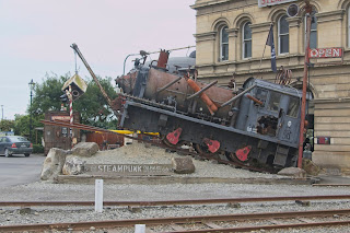
Final stop before the airport was the historic town of Oamaru. The town retains a lovely collection of historic buildings and a steam train rail system. The town is also a popular location for viewing the little blue penguins (but once again I was not going to be there at the time you could see them (typically at dusk as they return from a day at sea fishing). Instead I did see more fur seals, and a colony of shag.


Gratuitously here is a photo of the only penguin I managed to see on the trip ;->

Just a further 3.5 hour drive gets me back to Christchurch to drop off the campervan at Jucy and head over to the airport to begin the flights home. It has been a fantastic month!
Hiked/walked: 134 kilometers
Flights climbed: 400 floors
Boots done… and tossed - broken through at the toe and tread is bare…


Now in The Catlins...an area in the southeastern corner of the South Island of New Zealand. The area lies between Balclutha and Invercargill, straddling the boundary between the Otago and Southland regions. It includes the South Island's southernmost point, Slope Point.
Waipapa Point & lighthouse. Oldest wood built lighthouse in NZ. Sea lion as sunning on the shore and then rolling in the sand to add sun block.


Onwards through a pretty rolling hills landscape on a road with twists and turns. Took side road down to Slope Point. Then a 27 minute return walk through sheep pasture to the southern most NZ mainland point.


Driving on through a series of scenic reserves on some of the twistiest roads I’ve driven on. Destination Purakanui Falls. A lovely short walk along the cascading river feeding the falls. Interesting vegetation along the way including Think Bark Tutara trees.


The drive in was on several kms of gravel. Departure still on gravel till a few km paved and the more more more gravel to Jack’s Blowhole. The blowhole is 55 meters deep, 144 meters long, 68 meters wide, and 200 meters inland from the sea. More of a wave bore than a blowhole, although I guess if the wave action was strong enough the water height could be huge.


After about 40km of gravel the paved roads were back and my Jucy dust covered. Cheekily some rain came but not enough to wash the vehicle clean!
Nugget Point Lighthouse is located on high on a cliff on a spit of land with a very treacherous shore below. The lighthouse is quaint and still functional but the awesomeness comes from its location and the geography around it. A fur seal was swimming in the water way below, and Royal Spoonbills huddled on another nugget outcropping.


Finally pulled into the campground at 5:30pm - a much longer day on the road then I’ve been used to. But a very worthwhile drive through part of The Catlins to get here.

LAST DAY
I had thought about heading over to the Taiaroa Headland to see the albatross - but the drive to Christchurch is going to be 5 hours and I’m not up for another 45 minutes each way to take in those birds…Moeraki Boulders - one hour north of Dunedin. Interesting ball shaped boulders on a sandy beach. Fascinating how mother nature creates things like these boulders. Some of the boulders were broken open and the composite is slightly porous and slightly glassy.


Final stop before the airport was the historic town of Oamaru. The town retains a lovely collection of historic buildings and a steam train rail system. The town is also a popular location for viewing the little blue penguins (but once again I was not going to be there at the time you could see them (typically at dusk as they return from a day at sea fishing). Instead I did see more fur seals, and a colony of shag.


Gratuitously here is a photo of the only penguin I managed to see on the trip ;->

Just a further 3.5 hour drive gets me back to Christchurch to drop off the campervan at Jucy and head over to the airport to begin the flights home. It has been a fantastic month!
The end... this time...
Distance driven: 1,961 kilometersHiked/walked: 134 kilometers
Flights climbed: 400 floors
Boots done… and tossed - broken through at the toe and tread is bare…


